


Les auvergnats j-7

albert318
User
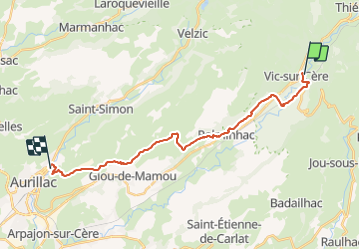

Length
21 km

Max alt
891 m

Uphill gradient
538 m
Km-Effort
28 km

Min alt
625 m

Downhill gradient
576 m
Boucle
No
Creation date :
2015-07-16 00:00:00.0
Updated on :
2015-07-16 00:00:00.0
6h00
Difficulty : Medium

FREE GPS app for hiking
 SityTrail
IGN / Geographical institutes
SityTrail Plus
The world is yours!
About
Trail Walking of 21 km to be discovered at Auvergne-Rhône-Alpes, Cantal, Vic-sur-Cère. This trail is proposed by albert318.
Positioning
Country:
France
Region :
Auvergne-Rhône-Alpes
Department/Province :
Cantal
Municipality :
Vic-sur-Cère
Location:
Unknown
Start:(Dec)
Start:(UTM)
470847 ; 4980882 (31T) N.
Comments