


Chartres de Bretagne

nolsim
User
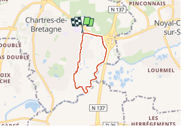

Length
4.5 km

Max alt
38 m

Uphill gradient
26 m
Km-Effort
4.8 km

Min alt
18 m

Downhill gradient
27 m
Boucle
Yes
Creation date :
2025-05-18 12:27:52.53
Updated on :
2025-05-18 13:29:04.517
1h00
Difficulty : Very easy

FREE GPS app for hiking
 SityTrail
IGN / Geographical institutes
SityTrail Plus
The world is yours!
About
Trail Walking of 4.5 km to be discovered at Brittany, Ille-et-Vilaine, Chartres-de-Bretagne. This trail is proposed by nolsim.
Positioning
Country:
France
Region :
Brittany
Department/Province :
Ille-et-Vilaine
Municipality :
Chartres-de-Bretagne
Location:
Unknown
Start:(Dec)
Start:(UTM)
597198 ; 5321708 (30U) N.
Comments