


Chatel - pointe des Mattes

marcel.F
User
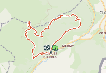

Length
10.9 km

Max alt
2007 m

Uphill gradient
890 m
Km-Effort
23 km

Min alt
1174 m

Downhill gradient
888 m
Boucle
Yes
Creation date :
2025-05-18 07:06:08.608
Updated on :
2025-05-18 15:58:02.806
5h10
Difficulty : Very difficult

FREE GPS app for hiking
 SityTrail
IGN / Geographical institutes
SityTrail Plus
The world is yours!
About
Trail Walking of 10.9 km to be discovered at Auvergne-Rhône-Alpes, Upper Savoy, Châtel. This trail is proposed by marcel.F.
Positioning
Country:
France
Region :
Auvergne-Rhône-Alpes
Department/Province :
Upper Savoy
Municipality :
Châtel
Location:
Unknown
Start:(Dec)
Start:(UTM)
331145 ; 5124172 (32T) N.
Comments