


Chevreuil direction les Nans

tigrou31
User
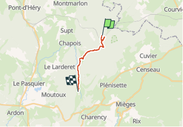

Length
9.9 km

Max alt
850 m

Uphill gradient
196 m
Km-Effort
12.8 km

Min alt
654 m

Downhill gradient
275 m
Boucle
No
Creation date :
2025-05-18 12:18:47.129
Updated on :
2025-05-18 15:33:22.264
3h14
Difficulty : Difficult

FREE GPS app for hiking
 SityTrail
IGN / Geographical institutes
SityTrail Plus
The world is yours!
About
Trail Walking of 9.9 km to be discovered at Bourgogne-Franche-Comté, Jura, Supt. This trail is proposed by tigrou31.
Positioning
Country:
France
Region :
Bourgogne-Franche-Comté
Department/Province :
Jura
Municipality :
Supt
Location:
Unknown
Start:(Dec)
Start:(UTM)
271725 ; 5192368 (32T) N.
Comments