


Bastille Vincennes réalise

tine60
User
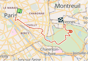

Length
15.2 km

Max alt
60 m

Uphill gradient
128 m
Km-Effort
16.9 km

Min alt
30 m

Downhill gradient
109 m
Boucle
No
Creation date :
2025-05-20 07:59:41.0
Updated on :
2025-05-20 14:30:37.933

FREE GPS app for hiking
 SityTrail
IGN / Geographical institutes
SityTrail Plus
The world is yours!
About
Trail of 15.2 km to be discovered at Ile-de-France, Paris, Paris. This trail is proposed by tine60.

Positioning
Country:
France
Region :
Ile-de-France
Department/Province :
Paris
Municipality :
Paris
Location:
12th Arrondissement
Start:(Dec)
Start:(UTM)
453704 ; 5411226 (31U) N.
Comments