


rando gps descente directe

rouky
User
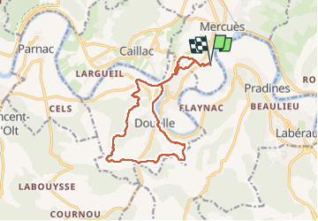

Length
15.2 km

Max alt
307 m

Uphill gradient
516 m
Km-Effort
22 km

Min alt
104 m

Downhill gradient
515 m
Boucle
Yes
Creation date :
2025-05-21 05:14:48.521
Updated on :
2025-05-21 08:36:22.266
3h17
Difficulty : Very difficult

FREE GPS app for hiking
 SityTrail
IGN / Geographical institutes
SityTrail Plus
The world is yours!
About
Trail Walking of 15.2 km to be discovered at Occitania, Lot, Mercuès. This trail is proposed by rouky.
Positioning
Country:
France
Region :
Occitania
Department/Province :
Lot
Municipality :
Mercuès
Location:
Unknown
Start:(Dec)
Start:(UTM)
371349 ; 4927162 (31T) N.
Comments