


2025-05-21 Rando Breuillet

jchezlemas
User
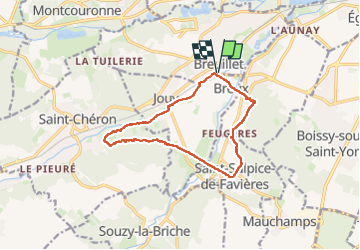

Length
12.2 km

Max alt
121 m

Uphill gradient
192 m
Km-Effort
14.8 km

Min alt
56 m

Downhill gradient
192 m
Boucle
Yes
Creation date :
2025-05-21 06:55:13.868
Updated on :
2025-05-21 16:53:36.761
2h58
Difficulty : Easy

FREE GPS app for hiking
 SityTrail
IGN / Geographical institutes
SityTrail Plus
The world is yours!
About
Trail Walking of 12.2 km to be discovered at Ile-de-France, Essonne, Breuillet. This trail is proposed by jchezlemas.
Positioning
Country:
France
Region :
Ile-de-France
Department/Province :
Essonne
Municipality :
Breuillet
Location:
Unknown
Start:(Dec)
Start:(UTM)
438966 ; 5379423 (31U) N.
Comments