


Poligné TA 22-05-25

nolsim
User
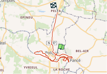

Length
16.1 km

Max alt
97 m

Uphill gradient
213 m
Km-Effort
19 km

Min alt
15 m

Downhill gradient
238 m
Boucle
No
Creation date :
2025-05-22 12:00:54.555
Updated on :
2025-05-22 15:17:40.183
3h16
Difficulty : Easy

FREE GPS app for hiking
 SityTrail
IGN / Geographical institutes
SityTrail Plus
The world is yours!
About
Trail Walking of 16.1 km to be discovered at Brittany, Ille-et-Vilaine, Poligné. This trail is proposed by nolsim.
Positioning
Country:
France
Region :
Brittany
Department/Province :
Ille-et-Vilaine
Municipality :
Poligné
Location:
Unknown
Start:(Dec)
Start:(UTM)
598637 ; 5304542 (30T) N.
Comments