


Sainte croix

raygautier
User
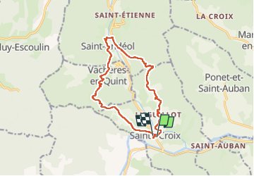

Length
14.7 km

Max alt
635 m

Uphill gradient
556 m
Km-Effort
22 km

Min alt
377 m

Downhill gradient
548 m
Boucle
Yes
Creation date :
2025-05-22 08:08:38.0
Updated on :
2025-05-22 16:59:40.466
6h06
Difficulty : Very difficult

FREE GPS app for hiking
 SityTrail
IGN / Geographical institutes
SityTrail Plus
The world is yours!
About
Trail Walking of 14.7 km to be discovered at Auvergne-Rhône-Alpes, Drôme, Sainte-Croix. This trail is proposed by raygautier.
Positioning
Country:
France
Region :
Auvergne-Rhône-Alpes
Department/Province :
Drôme
Municipality :
Sainte-Croix
Location:
Unknown
Start:(Dec)
Start:(UTM)
680710 ; 4959744 (31T) N.
Comments