


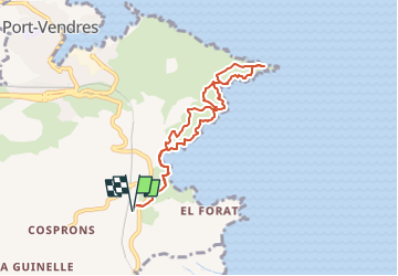
De l'anse de Paulilles au sémaphore

SoleilMoussanais
User

Length
7.6 km

Max alt
64 m

Uphill gradient
187 m
Km-Effort
10.1 km

Min alt
0 m

Downhill gradient
187 m
Boucle
Yes
Creation date :
2025-05-22 17:35:35.132
Updated on :
2025-05-22 17:43:18.322
2h18
Difficulty : Medium

FREE GPS app for hiking
 SityTrail
IGN / Geographical institutes
SityTrail Plus
The world is yours!
About
Trail Walking of 7.6 km to be discovered at Occitania, Pyrénées-Orientales, Port-Vendres. This trail is proposed by SoleilMoussanais.
Description
belle randonnée le long de la côte catalane.
A faire avec casquette et réserve d'eau.
Positioning
Country:
France
Region :
Occitania
Department/Province :
Pyrénées-Orientales
Municipality :
Port-Vendres
Location:
Unknown
Start:(Dec)
Start:(UTM)
509733 ; 4705209 (31T) N.
Comments