


Villers sec

topnature !
User
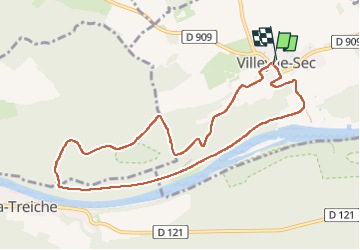

Length
9.3 km

Max alt
332 m

Uphill gradient
159 m
Km-Effort
11.4 km

Min alt
216 m

Downhill gradient
160 m
Boucle
Yes
Creation date :
2025-05-23 12:04:43.0
Updated on :
2025-05-23 14:46:32.739
2h17
Difficulty : Easy

FREE GPS app for hiking
 SityTrail
IGN / Geographical institutes
SityTrail Plus
The world is yours!
About
Trail Walking of 9.3 km to be discovered at Grand Est, Meurthe-et-Moselle, Villey-le-Sec. This trail is proposed by topnature !.
Positioning
Country:
France
Region :
Grand Est
Department/Province :
Meurthe-et-Moselle
Municipality :
Villey-le-Sec
Location:
Unknown
Start:(Dec)
Start:(UTM)
719214 ; 5393862 (31U) N.
Comments