


20250524-rouenles eglises

doudet
User
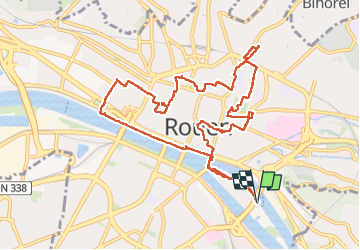

Length
11.3 km

Max alt
63 m

Uphill gradient
132 m
Km-Effort
13.1 km

Min alt
-4 m

Downhill gradient
132 m
Boucle
Yes
Creation date :
2025-05-24 11:48:20.687
Updated on :
2025-05-25 07:18:24.467
3h10
Difficulty : Easy

FREE GPS app for hiking
 SityTrail
IGN / Geographical institutes
SityTrail Plus
The world is yours!
About
Trail Walking of 11.3 km to be discovered at Normandy, Seine-Maritime, Rouen. This trail is proposed by doudet.
Description
Boucle A-R au départ de la patinoire de Rouen
Photos

Positioning
Country:
France
Region :
Normandy
Department/Province :
Seine-Maritime
Municipality :
Rouen
Location:
Unknown
Start:(Dec)
Start:(UTM)
362542 ; 5477195 (31U) N.
Comments