


J5 autour de Jaujac

CABERMAT
User
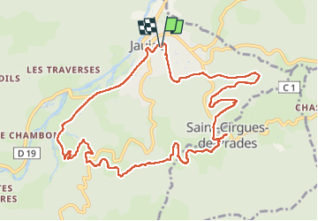

Length
12.8 km

Max alt
580 m

Uphill gradient
318 m
Km-Effort
17.1 km

Min alt
392 m

Downhill gradient
319 m
Boucle
Yes
Creation date :
2025-05-24 17:36:10.643
Updated on :
2025-05-28 14:14:26.136
5h18
Difficulty : Difficult

FREE GPS app for hiking
 SityTrail
IGN / Geographical institutes
SityTrail Plus
The world is yours!
About
Trail Walking of 12.8 km to be discovered at Auvergne-Rhône-Alpes, Ardèche, Jaujac. This trail is proposed by CABERMAT.
Positioning
Country:
France
Region :
Auvergne-Rhône-Alpes
Department/Province :
Ardèche
Municipality :
Jaujac
Location:
Unknown
Start:(Dec)
Start:(UTM)
599808 ; 4943314 (31T) N.
Comments