


fort liouville

ISAGIL
User
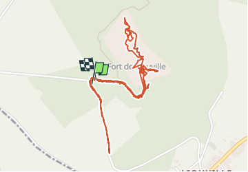

Length
4.3 km

Max alt
388 m

Uphill gradient
43 m
Km-Effort
4.9 km

Min alt
360 m

Downhill gradient
41 m
Boucle
Yes
Creation date :
2025-05-25 11:31:10.087
Updated on :
2025-05-25 15:52:25.885
4h20
Difficulty : Easy

FREE GPS app for hiking
 SityTrail
IGN / Geographical institutes
SityTrail Plus
The world is yours!
About
Trail Walking of 4.3 km to be discovered at Grand Est, Meuse, Apremont-la-Forêt. This trail is proposed by ISAGIL.
Description
fort
Photos


Positioning
Country:
France
Region :
Grand Est
Department/Province :
Meuse
Municipality :
Apremont-la-Forêt
Location:
Liouville
Start:(Dec)
Start:(UTM)
692258 ; 5411812 (31U) N.
Comments