


Lucinges - Les Voirons

marcel.F
User
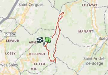

Length
13 km

Max alt
1456 m

Uphill gradient
595 m
Km-Effort
21 km

Min alt
1044 m

Downhill gradient
597 m
Boucle
Yes
Creation date :
2025-05-25 07:04:15.104
Updated on :
2025-05-25 16:31:12.255
6h10
Difficulty : Medium

FREE GPS app for hiking
 SityTrail
IGN / Geographical institutes
SityTrail Plus
The world is yours!
About
Trail Walking of 13 km to be discovered at Auvergne-Rhône-Alpes, Upper Savoy, Lucinges. This trail is proposed by marcel.F.
Positioning
Country:
France
Region :
Auvergne-Rhône-Alpes
Department/Province :
Upper Savoy
Municipality :
Lucinges
Location:
Unknown
Start:(Dec)
Start:(UTM)
294506 ; 5119975 (32T) N.
Comments