


Croix bague

audrey54
User
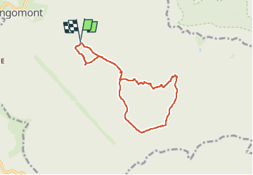

Length
7.2 km

Max alt
574 m

Uphill gradient
244 m
Km-Effort
10.4 km

Min alt
407 m

Downhill gradient
243 m
Boucle
Yes
Creation date :
2025-05-28 07:55:52.0
Updated on :
2025-05-28 10:46:09.505
2h15
Difficulty : Unknown

FREE GPS app for hiking
 SityTrail
IGN / Geographical institutes
SityTrail Plus
The world is yours!
About
Trail Walking of 7.2 km to be discovered at Grand Est, Meurthe-et-Moselle, Angomont. This trail is proposed by audrey54.

Positioning
Country:
France
Region :
Grand Est
Department/Province :
Meurthe-et-Moselle
Municipality :
Angomont
Location:
Unknown
Start:(Dec)
Start:(UTM)
349474 ; 5375027 (32U) N.
Comments