


Rando tutorat JLA Machault

jeanmarcMasson
User GUIDE

Length
15.7 km

Max alt
116 m

Uphill gradient
193 m
Km-Effort
18.3 km

Min alt
66 m

Downhill gradient
193 m
Boucle
Yes
Creation date :
2025-05-28 08:31:35.591
Updated on :
2025-05-28 14:07:41.283
3h52
Difficulty : Difficult

FREE GPS app for hiking
 SityTrail
IGN / Geographical institutes
SityTrail Plus
The world is yours!
About
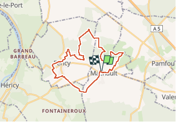
Trail Walking of 15.7 km to be discovered at Ile-de-France, Seine-et-Marne, Machault. This trail is proposed by jeanmarcMasson.
Photos


Positioning
Country:
France
Region :
Ile-de-France
Department/Province :
Seine-et-Marne
Municipality :
Machault
Location:
Unknown
Start:(Dec)
Start:(UTM)
487374 ; 5366976 (31U) N.
Comments