


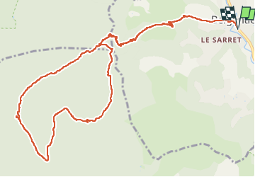
Pas de Belgentier

FSantoni
User


7h30
Difficulty : Very difficult

FREE GPS app for hiking
 SityTrail
IGN / Geographical institutes
SityTrail Plus
The world is yours!
About
Trail Walking of 16.4 km to be discovered at Provence-Alpes-Côte d'Azur, Var, Belgentier. This trail is proposed by FSantoni.
Description
A partir du village de Belgentier, belle rando de 16 km et plus de 700 m de dénivelé faite avec mon club des Excursionnistes Toulonnais.
Presque l'intégralité de la rando se fait à l'ombre, ce qui est non négligeable avec l'été qui pointe son nez.
Originalité dont on se serait bien passée : une des participantes à fait une chute dans une descente qui a nécessité le soutien du groupe et finalement l'intervention des pompiers.
La rando n'est pas une activité sans risque...
Photos


Positioning
Comments