


Projet Amicale_Rance Miserieux Toussieux

d.rognon
User
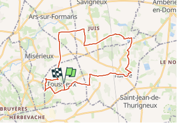

Length
18.3 km

Max alt
293 m

Uphill gradient
198 m
Km-Effort
21 km

Min alt
226 m

Downhill gradient
197 m
Boucle
Yes
Creation date :
2025-05-28 16:09:31.284
Updated on :
2025-05-28 16:10:35.128
4h45
Difficulty : Very difficult

FREE GPS app for hiking
 SityTrail
IGN / Geographical institutes
SityTrail Plus
The world is yours!
About
Trail Walking of 18.3 km to be discovered at Auvergne-Rhône-Alpes, Ain, Toussieux. This trail is proposed by d.rognon.
Description
Selon Visorando
Positioning
Country:
France
Region :
Auvergne-Rhône-Alpes
Department/Province :
Ain
Municipality :
Toussieux
Location:
Unknown
Start:(Dec)
Start:(UTM)
641693 ; 5091341 (31T) N.
Comments