


Moncontour - Mon Jean 6km

jeanmarcMasson
User GUIDE
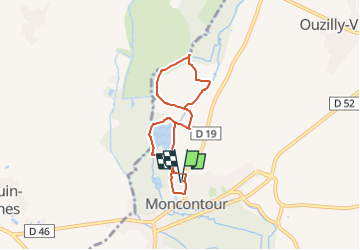

Length
6.2 km

Max alt
72 m

Uphill gradient
46 m
Km-Effort
6.8 km

Min alt
55 m

Downhill gradient
46 m
Boucle
Yes
Creation date :
2025-05-29 14:34:05.861
Updated on :
2025-05-29 14:34:09.063
1h33
Difficulty : Medium

FREE GPS app for hiking
 SityTrail
IGN / Geographical institutes
SityTrail Plus
The world is yours!
About
Trail Walking of 6.2 km to be discovered at New Aquitaine, Vienne, Moncontour. This trail is proposed by jeanmarcMasson.
Positioning
Country:
France
Region :
New Aquitaine
Department/Province :
Vienne
Municipality :
Moncontour
Location:
Unknown
Start:(Dec)
Start:(UTM)
727185 ; 5196586 (30T) N.
Comments