


Le dôme

raygautier
User
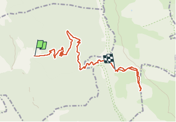

Length
9.7 km

Max alt
2033 m

Uphill gradient
1370 m
Km-Effort
24 km

Min alt
661 m

Downhill gradient
204 m
Boucle
No
Creation date :
2025-05-29 05:56:08.0
Updated on :
2025-05-29 16:53:18.372
6h04
Difficulty : Very difficult

FREE GPS app for hiking
 SityTrail
IGN / Geographical institutes
SityTrail Plus
The world is yours!
About
Trail Walking of 9.7 km to be discovered at Auvergne-Rhône-Alpes, Drôme, Die. This trail is proposed by raygautier.
Positioning
Country:
France
Region :
Auvergne-Rhône-Alpes
Department/Province :
Drôme
Municipality :
Die
Location:
Unknown
Start:(Dec)
Start:(UTM)
692589 ; 4957556 (31T) N.
Comments