


c0l

raygautier
User
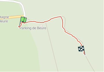

Length
292 m

Max alt
1433 m

Uphill gradient
28 m
Km-Effort
572 m

Min alt
1401 m

Downhill gradient
0 m
Boucle
No
Creation date :
2025-05-25 06:11:34.919
Updated on :
2025-05-30 15:17:34.686
8h08
Difficulty : Very easy

FREE GPS app for hiking
 SityTrail
IGN / Geographical institutes
SityTrail Plus
The world is yours!
About
Trail Walking of 292 m to be discovered at Auvergne-Rhône-Alpes, Drôme, Saint-Agnan-en-Vercors. This trail is proposed by raygautier.
Positioning
Country:
France
Region :
Auvergne-Rhône-Alpes
Department/Province :
Drôme
Municipality :
Saint-Agnan-en-Vercors
Location:
Unknown
Start:(Dec)
Start:(UTM)
691569 ; 4968292 (31T) N.
Comments