


20250531-gerberoy A-M

doudet
User
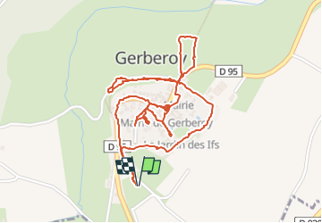

Length
3 km

Max alt
181 m

Uphill gradient
53 m
Km-Effort
3.8 km

Min alt
139 m

Downhill gradient
53 m
Boucle
Yes
Creation date :
2025-05-31 08:01:19.568
Updated on :
2025-06-01 16:04:34.307
1h06
Difficulty : Easy

FREE GPS app for hiking
 SityTrail
IGN / Geographical institutes
SityTrail Plus
The world is yours!
About
Trail Walking of 3 km to be discovered at Hauts-de-France, Oise, Gerberoy. This trail is proposed by doudet.
Photos

Positioning
Country:
France
Region :
Hauts-de-France
Department/Province :
Oise
Municipality :
Gerberoy
Location:
Unknown
Start:(Dec)
Start:(UTM)
416700 ; 5487221 (31U) N.
Comments