


2015-07-16 Rando Alpes Mancelles

jchezlemas
User
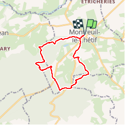

Length
13.3 km

Max alt
232 m

Uphill gradient
225 m
Km-Effort
16.3 km

Min alt
155 m

Downhill gradient
224 m
Boucle
Yes
Creation date :
2015-07-20 00:00:00.0
Updated on :
2015-07-20 00:00:00.0
--
Difficulty : Easy

FREE GPS app for hiking
 SityTrail
IGN / Geographical institutes
SityTrail Plus
The world is yours!
About
Trail Walking of 13.3 km to be discovered at Pays de la Loire, Sarthe, Montreuil-le-Chétif. This trail is proposed by jchezlemas.
Positioning
Country:
France
Region :
Pays de la Loire
Department/Province :
Sarthe
Municipality :
Montreuil-le-Chétif
Location:
Unknown
Start:(Dec)
Start:(UTM)
720059 ; 5347881 (30U) N.
Comments