


cg06 bouyon les ferres bouyon

winkelmuller
User
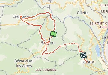

Length
22 km

Max alt
1008 m

Uphill gradient
942 m
Km-Effort
35 km

Min alt
263 m

Downhill gradient
1112 m
Boucle
No
Creation date :
2025-04-30 07:05:59.152
Updated on :
2025-06-01 05:43:14.32
7h55
Difficulty : Very difficult

FREE GPS app for hiking
 SityTrail
IGN / Geographical institutes
SityTrail Plus
The world is yours!
About
Trail Walking of 22 km to be discovered at Provence-Alpes-Côte d'Azur, Maritime Alps, Bouyon. This trail is proposed by winkelmuller.
Positioning
Country:
France
Region :
Provence-Alpes-Côte d'Azur
Department/Province :
Maritime Alps
Municipality :
Bouyon
Location:
Unknown
Start:(Dec)
Start:(UTM)
349279 ; 4854372 (32T) N.
Comments