


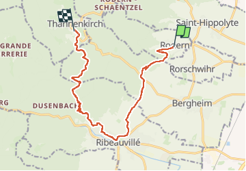
rodern-ribeauvillée-thannenkirch

winkelmuller
User

Length
14 km

Max alt
638 m

Uphill gradient
607 m
Km-Effort
21 km

Min alt
235 m

Downhill gradient
394 m
Boucle
No
Creation date :
2025-05-12 06:10:17.179
Updated on :
2025-06-01 05:43:19.219
7h17
Difficulty : Medium

FREE GPS app for hiking
 SityTrail
IGN / Geographical institutes
SityTrail Plus
The world is yours!
About
Trail Walking of 14 km to be discovered at Grand Est, Haut-Rhin, Rodern. This trail is proposed by winkelmuller.
Positioning
Country:
France
Region :
Grand Est
Department/Province :
Haut-Rhin
Municipality :
Rodern
Location:
Unknown
Start:(Dec)
Start:(UTM)
377672 ; 5342564 (32U) N.
Comments