


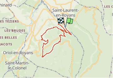
Pont des Chartreux st Laurent en Royans

alinetpierre
User

Length
15.8 km

Max alt
912 m

Uphill gradient
824 m
Km-Effort
27 km

Min alt
241 m

Downhill gradient
825 m
Boucle
Yes
Creation date :
2025-06-01 06:10:17.0
Updated on :
2025-07-27 17:20:44.241
6h05
Difficulty : Very difficult

FREE GPS app for hiking
 SityTrail
IGN / Geographical institutes
SityTrail Plus
The world is yours!
About
Trail Walking of 15.8 km to be discovered at Auvergne-Rhône-Alpes, Drôme, Saint-Laurent-en-Royans. This trail is proposed by alinetpierre.
Description
Randonnée avec Azur , juste sublime
Photos


Positioning
Country:
France
Region :
Auvergne-Rhône-Alpes
Department/Province :
Drôme
Municipality :
Saint-Laurent-en-Royans
Location:
Unknown
Start:(Dec)
Start:(UTM)
683278 ; 4987365 (31T) N.
Comments