


dieulouard

ISAGIL
User
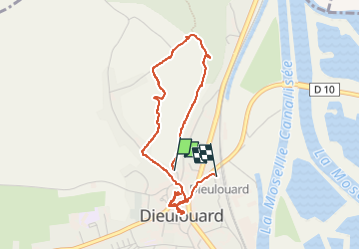

Length
3.7 km

Max alt
263 m

Uphill gradient
72 m
Km-Effort
4.7 km

Min alt
182 m

Downhill gradient
86 m
Boucle
No
Creation date :
2025-06-01 12:13:47.276
Updated on :
2025-06-01 15:16:15.783
3h01
Difficulty : Easy

FREE GPS app for hiking
 SityTrail
IGN / Geographical institutes
SityTrail Plus
The world is yours!
About
Trail Walking of 3.7 km to be discovered at Grand Est, Meurthe-et-Moselle, Dieulouard. This trail is proposed by ISAGIL.
Photos


Positioning
Country:
France
Region :
Grand Est
Department/Province :
Meurthe-et-Moselle
Municipality :
Dieulouard
Location:
Unknown
Start:(Dec)
Start:(UTM)
284872 ; 5414283 (32U) N.
Comments