


micheldutilleul
User
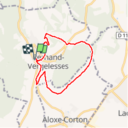

Length
6.2 km

Max alt
381 m

Uphill gradient
175 m
Km-Effort
8.6 km

Min alt
259 m

Downhill gradient
176 m
Boucle
Yes
Creation date :
2015-07-22 00:00:00.0
Updated on :
2015-07-22 00:00:00.0
2h00
Difficulty : Medium

FREE GPS app for hiking
 SityTrail
IGN / Geographical institutes
SityTrail Plus
The world is yours!
About
Trail Walking of 6.2 km to be discovered at Bourgogne-Franche-Comté, Côte-d'Or, Pernand-Vergelesses. This trail is proposed by micheldutilleul.
Positioning
Country:
France
Region :
Bourgogne-Franche-Comté
Department/Province :
Côte-d'Or
Municipality :
Pernand-Vergelesses
Location:
Unknown
Start:(Dec)
Start:(UTM)
640394 ; 5215640 (31T) N.
Comments
très bien