


Vigny

avdem
User
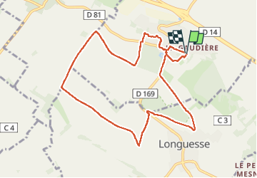

Length
9.6 km

Max alt
93 m

Uphill gradient
133 m
Km-Effort
11.3 km

Min alt
55 m

Downhill gradient
133 m
Boucle
Yes
Creation date :
2025-06-03 07:35:34.352
Updated on :
2025-06-03 10:17:41.022
2h41
Difficulty : Easy

FREE GPS app for hiking
 SityTrail
IGN / Geographical institutes
SityTrail Plus
The world is yours!
About
Trail Walking of 9.6 km to be discovered at Ile-de-France, Val-d'Oise, Vigny. This trail is proposed by avdem.
Description
facile
Photos


Positioning
Country:
France
Region :
Ile-de-France
Department/Province :
Val-d'Oise
Municipality :
Vigny
Location:
Unknown
Start:(Dec)
Start:(UTM)
422002 ; 5436548 (31U) N.
Comments