


rando gourmande hirondelle

cps46
User
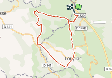

Length
11.5 km

Max alt
265 m

Uphill gradient
278 m
Km-Effort
15.2 km

Min alt
156 m

Downhill gradient
279 m
Boucle
Yes
Creation date :
2015-07-21 00:00:00.0
Updated on :
2015-07-21 00:00:00.0
3h41
Difficulty : Unknown

FREE GPS app for hiking
 SityTrail
IGN / Geographical institutes
SityTrail Plus
The world is yours!
About
Trail Walking of 11.5 km to be discovered at Occitania, Lot, Loupiac. This trail is proposed by cps46.
Photos


Positioning
Country:
France
Region :
Occitania
Department/Province :
Lot
Municipality :
Loupiac
Location:
Unknown
Start:(Dec)
Start:(UTM)
378320 ; 4965741 (31T) N.
Comments