


Carignan

fra_depoorter
User
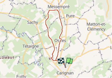

Length
12 km

Max alt
225 m

Uphill gradient
126 m
Km-Effort
13.7 km

Min alt
163 m

Downhill gradient
125 m
Boucle
Yes
Creation date :
2025-06-01 07:56:05.68
Updated on :
2025-06-04 11:46:45.125
2h39
Difficulty : Medium

FREE GPS app for hiking
 SityTrail
IGN / Geographical institutes
SityTrail Plus
The world is yours!
About
Trail Walking of 12 km to be discovered at Grand Est, Ardennes, Carignan. This trail is proposed by fra_depoorter.
Positioning
Country:
France
Region :
Grand Est
Department/Province :
Ardennes
Municipality :
Carignan
Location:
Unknown
Start:(Dec)
Start:(UTM)
656571 ; 5500396 (31U) N.
Comments