


CRET DE LA GOUTTE (METRAL) 13 Km, 900 m d+).

DUCLUZEAU
User
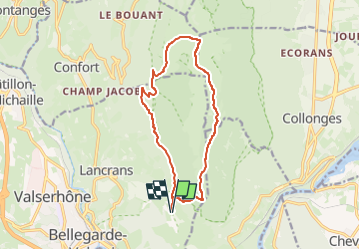

Length
13.4 km

Max alt
1611 m

Uphill gradient
886 m
Km-Effort
25 km

Min alt
764 m

Downhill gradient
886 m
Boucle
Yes
Creation date :
2025-06-05 16:54:05.538
Updated on :
2025-06-05 16:54:47.158
5h43
Difficulty : Difficult

FREE GPS app for hiking
 SityTrail
IGN / Geographical institutes
SityTrail Plus
The world is yours!
About
Trail Walking of 13.4 km to be discovered at Auvergne-Rhône-Alpes, Ain, Valserhône. This trail is proposed by DUCLUZEAU.
Positioning
Country:
France
Region :
Auvergne-Rhône-Alpes
Department/Province :
Ain
Municipality :
Valserhône
Location:
Bellegarde-sur-Valserine
Start:(Dec)
Start:(UTM)
720639 ; 5110804 (31T) N.
Comments