


Mijanes

c.chehere
User
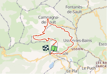

Length
18.1 km

Max alt
1766 m

Uphill gradient
994 m
Km-Effort
31 km

Min alt
971 m

Downhill gradient
993 m
Boucle
Yes
Creation date :
2014-12-10 00:00:00.0
Updated on :
2014-12-10 00:00:00.0
5h47
Difficulty : Medium

FREE GPS app for hiking
 SityTrail
IGN / Geographical institutes
SityTrail Plus
The world is yours!
About
Trail Walking of 18.1 km to be discovered at Occitania, Ariège, Mijanès. This trail is proposed by c.chehere.
Description
Col de la Sira
Positioning
Country:
France
Region :
Occitania
Department/Province :
Ariège
Municipality :
Mijanès
Location:
Unknown
Start:(Dec)
Start:(UTM)
422686 ; 4731204 (31T) N.
Comments