


Col de Fauvel

Linerou
User
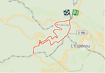

Length
7.7 km

Max alt
1344 m

Uphill gradient
116 m
Km-Effort
9.2 km

Min alt
1288 m

Downhill gradient
116 m
Boucle
Yes
Creation date :
2025-06-06 07:48:31.233
Updated on :
2025-06-06 10:03:13.603
1h51
Difficulty : Easy

FREE GPS app for hiking
 SityTrail
IGN / Geographical institutes
SityTrail Plus
The world is yours!
About
Trail Walking of 7.7 km to be discovered at Occitania, Gard, Val-d'Aigoual. This trail is proposed by Linerou.
Positioning
Country:
France
Region :
Occitania
Department/Province :
Gard
Municipality :
Val-d'Aigoual
Location:
Valleraugue
Start:(Dec)
Start:(UTM)
543391 ; 4883509 (31T) N.
Comments