


Etape 2 - GRR2

Ko-Rando
User

Length
21 km

Max alt
2271 m

Uphill gradient
640 m
Km-Effort
33 km

Min alt
935 m

Downhill gradient
1491 m
Boucle
No
Creation date :
2025-06-06 01:03:05.762
Updated on :
2025-08-05 08:23:34.597
7h32
Difficulty : Very difficult

FREE GPS app for hiking
 SityTrail
IGN / Geographical institutes
SityTrail Plus
The world is yours!
About
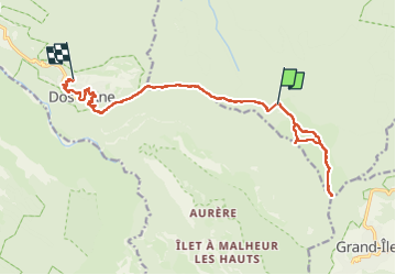
Trail Walking of 21 km to be discovered at Réunion, Unknown, Saint-Denis. This trail is proposed by Ko-Rando.
Description
Du gîte de la Roche écrite au sommet de la Roche écrite pour un magnifique levé de soleil.
Du sommet de la Roche écrite à Dos d'Ane. Préparez-vous à en prendre plein la vue !
Positioning
Country:
France
Region :
Réunion
Department/Province :
Unknown
Municipality :
Saint-Denis
Location:
Unknown
Start:(Dec)
Start:(UTM)
338275 ; 7678409 (40K) S.
Comments