


comice agricole

coglais
User

Length
4.8 km

Max alt
116 m

Uphill gradient
31 m
Km-Effort
5.2 km

Min alt
98 m

Downhill gradient
30 m
Boucle
Yes
Creation date :
2025-06-06 12:34:33.917
Updated on :
2025-06-06 12:40:10.125
1h11
Difficulty : Easy

FREE GPS app for hiking
 SityTrail
IGN / Geographical institutes
SityTrail Plus
The world is yours!
About
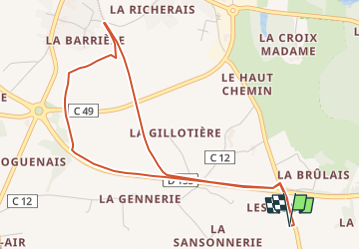
Trail Walking of 4.8 km to be discovered at Brittany, Ille-et-Vilaine, Maen-Roch. This trail is proposed by coglais.
Positioning
Country:
France
Region :
Brittany
Department/Province :
Ille-et-Vilaine
Municipality :
Maen-Roch
Location:
Saint-Étienne-en-Coglès
Start:(Dec)
Start:(UTM)
622091 ; 5361257 (30U) N.
Comments