


Ardes Mercoeur Rentières

alinetpierre
User
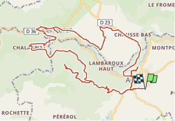

Length
16.8 km

Max alt
909 m

Uphill gradient
545 m
Km-Effort
24 km

Min alt
585 m

Downhill gradient
546 m
Boucle
Yes
Creation date :
2025-06-06 09:08:14.0
Updated on :
2025-06-06 14:04:59.56

FREE GPS app for hiking
 SityTrail
IGN / Geographical institutes
SityTrail Plus
The world is yours!
About
Trail of 16.8 km to be discovered at Auvergne-Rhône-Alpes, Puy-de-Dôme, Ardes. This trail is proposed by alinetpierre.
Description
Au départ de l’aire de camping car
Photos


Positioning
Country:
France
Region :
Auvergne-Rhône-Alpes
Department/Province :
Puy-de-Dôme
Municipality :
Ardes
Location:
Unknown
Start:(Dec)
Start:(UTM)
510154 ; 5027598 (31T) N.
Comments