


2025 06 chamcueuil t1

michel1025
User
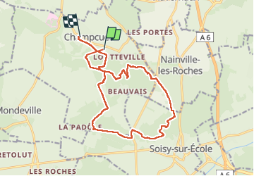

Length
16.2 km

Max alt
153 m

Uphill gradient
285 m
Km-Effort
20 km

Min alt
79 m

Downhill gradient
282 m
Boucle
No
Creation date :
2025-06-06 09:33:34.0
Updated on :
2025-06-06 15:14:16.558
4h05
Difficulty : Very difficult

FREE GPS app for hiking
 SityTrail
IGN / Geographical institutes
SityTrail Plus
The world is yours!
About
Trail Walking of 16.2 km to be discovered at Ile-de-France, Essonne, Champcueil. This trail is proposed by michel1025.
Positioning
Country:
France
Region :
Ile-de-France
Department/Province :
Essonne
Municipality :
Champcueil
Location:
Unknown
Start:(Dec)
Start:(UTM)
459940 ; 5373216 (31U) N.
Comments