


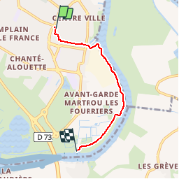
Rochefort - pont transbordeur

fredtruc27
User

Length
3.9 km

Max alt
15 m

Uphill gradient
17 m
Km-Effort
4.2 km

Min alt
-6 m

Downhill gradient
31 m
Boucle
No
Creation date :
2015-07-23 00:00:00.0
Updated on :
2015-07-23 00:00:00.0
25m
Difficulty : Unknown

FREE GPS app for hiking
 SityTrail
IGN / Geographical institutes
SityTrail Plus
The world is yours!
About
Trail Other activity of 3.9 km to be discovered at New Aquitaine, Charente-Maritime, Rochefort. This trail is proposed by fredtruc27.
Description
randonnée sur chemin goudronné le long de la Charente. plat
Photos


Positioning
Country:
France
Region :
New Aquitaine
Department/Province :
Charente-Maritime
Municipality :
Rochefort
Location:
Unknown
Start:(Dec)
Start:(UTM)
657690 ; 5089190 (30T) N.
Comments