


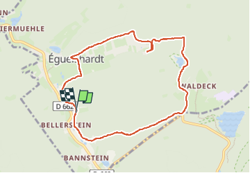
tour étangs et Eguelshardt

Cavaliers d’eguelshardt
A la découverte des chemins

Length
8.5 km

Max alt
296 m

Uphill gradient
106 m
Km-Effort
10 km

Min alt
240 m

Downhill gradient
108 m
Boucle
Yes
Creation date :
2025-06-09 12:54:36.4
Updated on :
2025-06-09 14:22:52.666
1h27
Difficulty : Very easy

FREE GPS app for hiking
 SityTrail
IGN / Geographical institutes
SityTrail Plus
The world is yours!
About
Trail Coupling of 8.5 km to be discovered at Grand Est, Moselle, Éguelshardt. This trail is proposed by Cavaliers d’eguelshardt .
Positioning
Country:
France
Region :
Grand Est
Department/Province :
Moselle
Municipality :
Éguelshardt
Location:
Unknown
Start:(Dec)
Start:(UTM)
390242 ; 5429896 (32U) N.
Comments