


cotteuge pic saint pierre pic de murat

jeanic63
User
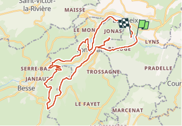

Length
23 km

Max alt
1007 m

Uphill gradient
812 m
Km-Effort
34 km

Min alt
637 m

Downhill gradient
804 m
Boucle
No
Creation date :
2025-06-09 06:22:01.316
Updated on :
2025-06-09 14:54:30.272
6h27
Difficulty : Very difficult

FREE GPS app for hiking
 SityTrail
IGN / Geographical institutes
SityTrail Plus
The world is yours!
About
Trail Walking of 23 km to be discovered at Auvergne-Rhône-Alpes, Puy-de-Dôme, Saint-Diéry. This trail is proposed by jeanic63.
Description
départ cotteuges
Positioning
Country:
France
Region :
Auvergne-Rhône-Alpes
Department/Province :
Puy-de-Dôme
Municipality :
Saint-Diéry
Location:
Saint-Diéry
Start:(Dec)
Start:(UTM)
500656 ; 5042549 (31T) N.
Comments