


Chemin des crêtes / Bonsgnée / Strivay / Amostrenne

Micmal
User
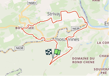

Length
9.8 km

Max alt
235 m

Uphill gradient
300 m
Km-Effort
13.8 km

Min alt
88 m

Downhill gradient
299 m
Boucle
Yes
Creation date :
2025-06-09 18:41:00.474
Updated on :
2025-06-09 18:42:52.79
3h08
Difficulty : Difficult

FREE GPS app for hiking
 SityTrail
IGN / Geographical institutes
SityTrail Plus
The world is yours!
About
Trail Walking of 9.8 km to be discovered at Wallonia, Liège, Esneux. This trail is proposed by Micmal.
Description
recopié
pause Strivay tilleul
Positioning
Country:
Belgium
Region :
Wallonia
Department/Province :
Liège
Municipality :
Esneux
Location:
Esneux
Start:(Dec)
Start:(UTM)
679681 ; 5599608 (31U) N.
Comments