


2025-06-10_10h03m22_perros guitec-ploubazlanec

Magali Sat
User
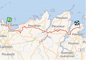

Length
45 km

Max alt
86 m

Uphill gradient
522 m
Km-Effort
51 km

Min alt
0 m

Downhill gradient
476 m
Boucle
No
Creation date :
2025-06-10 08:03:22.932
Updated on :
2025-06-10 08:03:25.579

FREE GPS app for hiking
 SityTrail
IGN / Geographical institutes
SityTrail Plus
The world is yours!
About
Trail of 45 km to be discovered at Brittany, Côtes-d'Armor, Perros-Guirec. This trail is proposed by Magali Sat.
Positioning
Country:
France
Region :
Brittany
Department/Province :
Côtes-d'Armor
Municipality :
Perros-Guirec
Location:
Unknown
Start:(Dec)
Start:(UTM)
466201 ; 5406875 (30U) N.
Comments