


capucins parcd

Thomasp
User
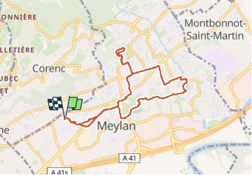

Length
9.3 km

Max alt
358 m

Uphill gradient
166 m
Km-Effort
11.5 km

Min alt
220 m

Downhill gradient
167 m
Boucle
Yes
Creation date :
2025-06-11 05:13:21.698
Updated on :
2025-06-11 07:59:23.542
2h10
Difficulty : Easy

FREE GPS app for hiking
 SityTrail
IGN / Geographical institutes
SityTrail Plus
The world is yours!
About
Trail Walking of 9.3 km to be discovered at Auvergne-Rhône-Alpes, Isère, Meylan. This trail is proposed by Thomasp.
Positioning
Country:
France
Region :
Auvergne-Rhône-Alpes
Department/Province :
Isère
Municipality :
Meylan
Location:
Unknown
Start:(Dec)
Start:(UTM)
717188 ; 5010097 (31T) N.
Comments