


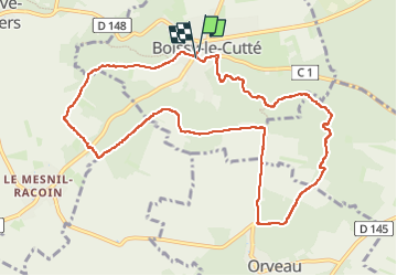
2025-06-11 Rando Boissy le Cutté

jchezlemas
User


2h52
Difficulty : Easy

FREE GPS app for hiking
 SityTrail
IGN / Geographical institutes
SityTrail Plus
The world is yours!
About
Trail Walking of 10.9 km to be discovered at Ile-de-France, Essonne, Boissy-le-Cutté. This trail is proposed by jchezlemas.
Description
-------------------------------------------------------------------------------------------
Rando de Martine et Alain Gauthier
Office de Tourisme de l'Arpajonnais
https://www.ot-coeuressonne.fr/
-------------------------------------------------------------------------------------------
Positioning
Comments