


Projet_Amicale_Bdf

d.rognon
User
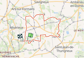

Length
16.5 km

Max alt
293 m

Uphill gradient
158 m
Km-Effort
18.6 km

Min alt
233 m

Downhill gradient
160 m
Boucle
No
Creation date :
2025-06-11 15:25:40.644
Updated on :
2025-06-11 15:34:12.275
4h13
Difficulty : Difficult

FREE GPS app for hiking
 SityTrail
IGN / Geographical institutes
SityTrail Plus
The world is yours!
About
Trail Walking of 16.5 km to be discovered at Auvergne-Rhône-Alpes, Ain, Toussieux. This trail is proposed by d.rognon.
Description
Randonnée du mardi 17 juin 2025
Reconnue par Jean-Claude et Robert
Positioning
Country:
France
Region :
Auvergne-Rhône-Alpes
Department/Province :
Ain
Municipality :
Toussieux
Location:
Unknown
Start:(Dec)
Start:(UTM)
641600 ; 5091317 (31T) N.
Comments