


SityTrail - 4488818 - plume-plus

raygautier
User
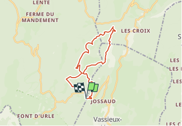

Length
13.7 km

Max alt
1562 m

Uphill gradient
576 m
Km-Effort
21 km

Min alt
1324 m

Downhill gradient
572 m
Boucle
Yes
Creation date :
2025-06-11 17:19:13.0
Updated on :
2025-06-11 17:19:14.546

FREE GPS app for hiking
 SityTrail
IGN / Geographical institutes
SityTrail Plus
The world is yours!
About
Trail of 13.7 km to be discovered at Auvergne-Rhône-Alpes, Drôme, Bouvante. This trail is proposed by raygautier.
Positioning
Country:
France
Region :
Auvergne-Rhône-Alpes
Department/Province :
Drôme
Municipality :
Bouvante
Location:
Unknown
Start:(Dec)
Start:(UTM)
685983 ; 4975362 (31T) N.
Comments