


Saint Roman Aiguille

ysst
User
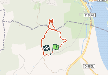

Length
3 km

Max alt
137 m

Uphill gradient
81 m
Km-Effort
4.1 km

Min alt
59 m

Downhill gradient
77 m
Boucle
Yes
Creation date :
2025-06-12 07:35:16.048
Updated on :
2025-06-12 08:06:38.872
30m
Difficulty : Very easy

FREE GPS app for hiking
 SityTrail
IGN / Geographical institutes
SityTrail Plus
The world is yours!
About
Trail Running of 3 km to be discovered at Occitania, Gard, Beaucaire. This trail is proposed by ysst.
Positioning
Country:
France
Region :
Occitania
Department/Province :
Gard
Municipality :
Beaucaire
Location:
Unknown
Start:(Dec)
Start:(UTM)
629424 ; 4854421 (31T) N.
Comments