


Etape 8 - GRR2

Ko-Rando
User

Length
16.6 km

Max alt
3057 m

Uphill gradient
2036 m
Km-Effort
39 km

Min alt
1199 m

Downhill gradient
761 m
Boucle
No
Creation date :
2025-06-12 03:04:38.762
Updated on :
2025-08-05 08:33:25.662
6h38
Difficulty : Very difficult

FREE GPS app for hiking
 SityTrail
IGN / Geographical institutes
SityTrail Plus
The world is yours!
About
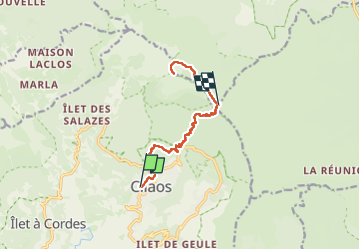
Trail Walking of 16.6 km to be discovered at Réunion, Unknown, Cilaos. This trail is proposed by Ko-Rando.
Description
De Cilaos au sommet du Piton des neiges.
Haaa le Piton des neiges !!! Une beauté !! Je l'ai fais de jour car la fenêtre météo pour le levé du soleil n'était pas bonne.
Positioning
Country:
France
Region :
Réunion
Department/Province :
Unknown
Municipality :
Cilaos
Location:
Unknown
Start:(Dec)
Start:(UTM)
341012 ; 7662031 (40K) S.
Comments